
Innovations

Product Innovations is a product that focuses on developing advanced technologies to create new capabilities for organizations. Through the integration of AI, advanced analytics, remote sensing, geospatial intelligence, and modern digital platforms, we help companies transform more quickly, efficiently, and sustainably. Each innovation we produce is designed to deliver future-relevant, adaptive solutions that can increase competitiveness in various industrial sectors
Business Solutions
Our Business Solutions provide end-to-end support designed to optimize operations, enhance efficiency, and accelerate growth. Through integrated technologies and strategic approaches, we help businesses transform challenges into opportunities and achieve sustainable success.
Digital Transformation Solutions
Geospatial & Remote Sensing Intelligence Solutions
Smart Operations Solutions
Our Services
Our services are designed to deliver tailored solutions that meet your business needs, combining advanced technology, expert insights, and reliable execution to help you achieve your goals efficiently and effectively.
Advance Technology Solutions
Modern technology-based solutions designed to improve efficiency, strengthen operational capabilities, and help businesses adapt to evolving industry needs.
Advanced SAR & Remote Sensing Intelligence
Synthetic Aperture Radar (SAR)-based intelligence services and remote sensing technology to provide accurate geospatial analysis, area monitoring, change detection, and data-driven decision making.
Smart Operations Solutions
Smart operational solutions that integrate automation, IoT, and analytics to increase productivity, simplify processes, and ensure full control and visibility in operations.
Information Technology Solutions
Comprehensive IT services covering infrastructure, system integration, security, and digital transformation to ensure your business runs smoothly, securely, and is ready to grow.
Software Development
Development of customized software according to business needs, ranging from web and mobile applications to enterprise systems, with a focus on quality, scalability, and user experience.
Data & AI
Data processing and artificial intelligence services to help businesses gain strategic insights, optimize processes, predict opportunities, and make faster and more accurate decisions.
Our Portfolio

RADAR INTEGRATED ANTENNA TECHNOLOGY
Client: Corporate / Business Clients
Country: Japan 🇯🇵
Radar Integrated Antenna Technology is a radar-based monitoring system designed to support real-time observation and analysis of areas with a high degree of accuracy. This system integrates radar data processing with an intuitive centralized dashboard, allowing users to monitor the condition of objects and the environment, detect movements and anomalies, and utilize historical data as a basis for evaluation and decision making. This solution is intended to improve antenna system reliability and support operational efficiency in a variety of needs, ranging from infrastructure monitoring to safety and strategic analysis.


Key Feature:
Impact:
- Integrated Radar Dashboard
Real-time radar data visualization in a centralized platform. - Movement & Anomaly Detection
Movement analysis and anomaly identification for early detection of potential risks. - Historical Data Analysis
Storage and analysis of historical data for performance and trend evaluation. - High-Accuracy Radar Processing
High-precision radar data processing to support reliable analysis. - User-Friendly Interface
An intuitive interface that facilitates data interpretation and decision making.
- It can be used by radar operators, operational teams, engineers, and decision makers to support infrastructure management, safety, and strategic analysis based on radar data.
- Provides an integrated radar monitoring system that presents real-time and historical insights for area surveillance and antenna system reliability.
- The system operates continuously in daily monitoring activities and serves as the primary support system when anomalies or risky conditions are detected.
- Applicable to areas with high monitoring needs, including strategic infrastructure, vital facilities, and radar operational environments.
- Increases situational awareness, accelerates response to potential risks, optimizes operational efficiency, and maintains the performance and reliability of radar antenna systems.

SNS DASHBOARD ANALYTICS
Client: Individual Clients
Country: Japan 🇯🇵
SNS Dashboard Analytics is an integrated analytics platform designed to comprehensively monitor, compare, and analyze the performance of key social media accounts and competitors in a single unified dashboard. This platform combines multi-platform monitoring with AI-based analysis to provide in-depth insights into content performance, audience behavior, and the effectiveness of digital strategies, thereby supporting fast, accurate, and data-driven decision making.

Key Feature:
Impact:
- Account & Competitor Comparison: Periodic comparative analysis of the performance of the main account with competitor accounts.
- AI-Based Content Analysis:
– Thumbnail analysis
– Video content analysis
– In-Depth analysis - Engagement & Audience Analytics: In-depth analysis of likes, comments, shares, viewing duration, and audience interactions.
- Deep & Historical Analysis: Access to historical data for evaluating long-term trends and performance.
- Interactive Data Visualization: Intuitive, easy-to-understand data display, ready for use in reports and presentations.
- It can be used by digital marketing teams, brand managers, content strategists, communications teams, and decision makers to monitor, evaluate, and optimize brand performance and digital strategies on social media.
- Provides an integrated analytics platform that delivers comprehensive insights into content performance, digital campaign effectiveness, audience behavior, and brand positioning compared to competitors.
- Used in real-time for daily performance monitoring, as well as periodically for campaign evaluation, trend analysis, and planning of future content strategies.
- Accessed through a centralized web-based dashboard that supports internal company analytics needs and cross-team collaboration on a single platform.
- Gain insights into audience trends and preferences, enhance engagement and the effectiveness of digital strategies, optimize brand positioning on social media, and support faster, more accurate, data-driven decision-making.
AI DISASTER PLATFORM
Client: Corporate / Business Clients
Country: Japan 🇯🇵
The AI Disaster Mitigation Platform is a web-based solution designed to support integrated disaster monitoring, analysis, and mitigation through interactive maps and AI technology. This platform combines various layers of disaster prediction—ranging from meteorological disasters, land disasters, to evacuation routes—into a single, easy-to-use integrated system. With color-coded risk visualization and real-time data, this platform helps users quickly and accurately understand the conditions of affected areas, while supporting more effective decision-making in emergency situations and long-term mitigation planning.

Key Feature:
Impact:
- Multi-Disaster Prediction Layers: Prediction of meteorological disasters (rainfall, typhoons), land disasters (earthquakes), and regional risks.
- Interactive Disaster Map: Interactive map with risk level visualization (Low, Moderate, High, Severe).
- Evacuation Route Recommendation: Recommendations for evacuation routes from high-risk areas to safe areas.
- Real-Time & Historical Data Visualization: Access to current disaster data and historical data for trend analysis.
- Facility & Emergency Point Mapping: Information on the locations of major hospitals, emergency hospitals, and evacuation points.
- Admin Layer Management System: Features for uploading, editing, deleting, and setting the visibility of disaster data for administrators.
- User-Friendly Dashboard: Intuitive interface for general users and stakeholders.
- Can be used by governments and disaster management agencies, emergency response teams and first responders, the general public and local communities, as well as regional planners and policy makers to support disaster preparedness, response, and mitigation planning.
- Provides an integrated disaster monitoring and analysis platform that presents real-time and historical risk information, interactive maps, and evacuation route recommendations to support data-driven disaster mitigation and response.
- Used before a disaster for planning and mitigation, during a disaster for rapid response and evacuation navigation, and after a disaster for impact assessment and post-disaster analysis.
- Implemented in disaster-prone areas, both urban and regional, and accessible online via desktop or laptop devices through a web-based platform.
- Reduces the risk of casualties and losses, improves preparedness and situational awareness, strengthens coordination among stakeholders, and accelerates response and improves the overall effectiveness of disaster mitigation.


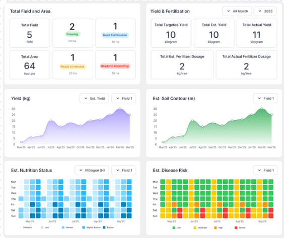
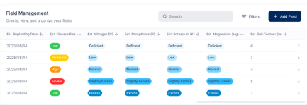
AGRICULTURE MONITORING
Client: Government
Country: Indonesia 🇮🇩
The Agriculture Monitoring System is an integrated, data-driven agricultural solution designed to enable real-time monitoring and analysis of land, crop, and environmental conditions. By combining sensor data, environmental monitoring, and interactive dashboards, the system provides comprehensive insights to support smarter agricultural planning, risk mitigation, and sustainable farming practices.
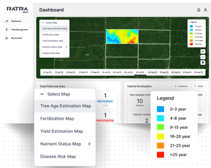
Key Feature:
Impact:
- Real-Time Environmental Monitoring: Continuous monitoring of soil conditions, weather parameters, and crop health
- Interactive Data Dashboard: Clear visualization of agricultural data for easy analysis and interpretation
- Historical Data & Trend Analysis: Tracking crop growth patterns and land condition changes over time
- Early Warning System: Alerts for potential risks such as drought, flooding, pest threats, or declining soil quality
- Decision Support Tools: Data-driven insights to support planning, intervention, and resource optimization
- The system can be used by farmers, agribusiness companies, agricultural planners, and policymakers to monitor land and crop conditions and support decision-making in agricultural management.
- Provides an integrated agricultural monitoring and analysis system that presents real-time and historical data on land, crop, and environmental conditions to improve visibility and control of agricultural operations.
- Used throughout the agricultural cycle for continuous monitoring, early detection of potential risks, and timely response to changes in environmental and crop conditions.
- Applicable to various agricultural areas, from small-scale farms to large-scale plantations, through an interactive dashboard-based system.
- Increase agricultural productivity, reduce crop failure risks, optimize resource use, and support more sustainable and data-driven agricultural practices.

Company
About Us
Careers
Training
Product
Innovations
Solutions
Resources
Articles
Portfolio
Features
Project Management
Business Solutions
Software Development
Data & AI
Head Office
The City Tower, Level 12 Unit 1-N, Jalan M.H. Thamrin No.81, Central Jakarta, Indonesia 10310
Operations Office
HQuarters Business Residence, UNIT 10-q, Jl. Asia Afrika No.158, Bandung, Jawa Barat 40261
Marketing Office
Jalan Terusan Ligar Raya No.1, Bukit Ligar, Bandung 40191
