
Jakarta, 8 May 2025 — PT Herdento Global Solusi (HGS) has successfully completed an advanced Oil Palm Plantation Remote Sensing-Based Mapping project for a leading Japanese technology company, delivering a suite of high-value plantation maps that will support the sustainable and profitable management of oil palm plantations in North Sumatra.
Indonesia is the world’s largest palm oil producer, with 16.38 million hectares of plantations generating over 50 million tons of crude palm oil in 2023. While the industry is a major economic driver, it faces critical challenges:
- Many plantations in Indonesia are still inspected manually, requiring significant time, labor, and cost to cover large areas.
- Fertilizer costs account for up to 40% of operating expenses, yet are often applied inefficiently.
- Declining yields due to aging trees, delayed replanting, and lack of accurate data.
- Disease threats such as Ganoderma boninense, causing annual industry losses exceeding IDR 4 trillion and affecting more than 118,000 hectares.
These challenges demand precise, timely, and spatially detailed information to guide plantation management toward efficiency, cost reduction, and long-term sustainability.
Project Focus
To address these challenges, the project applied advanced Synthetic Aperture Radar (SAR) and optical remote sensing with machine learning to produce high-resolution maps such as nutrient map, fertilization map, tree age estimation map, disease map, and productivity (yield estimation) map. This project concentrated on mapping key plantation indicators for oil palm in North Sumatra, laying a strong foundation for a comprehensive monitoring system that will support long-term yield optimization, replanting strategies, and resource allocation.
Deliverables
HGS have succeeded to develop this technology between October 2024 and May 2025, creating significant added value for the palm oil industry by:
Nutrient Map
HGS developed high-resolution maps identifying the spatial distribution of nitrogen (N), phosphorus (P), potassium (K), and magnesium (Mg) in oil palm leaves. These maps allow end-users to quickly identify nutrient-deficient blocks and prioritize fertilization efforts.
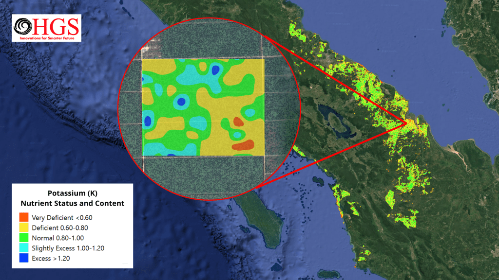
Sample of Nutrient Map
Fertilization Map
Based on nutrient distribution and established agronomic standards, HGS produced fertilization maps recommending site-specific dosages of Urea, TSP (Triple Super Phosphate), MoP (Muriate of Potash), and Dolomite. These recommendations are tailored to plantation age, nutrient status, and productivity targets. By using these maps, palm oil companies or end-users can increase the effectiveness of fertilization and reduce costs associated with fertilizer purchases, ultimately helping to improve company profits and strengthen the overall palm oil industry.
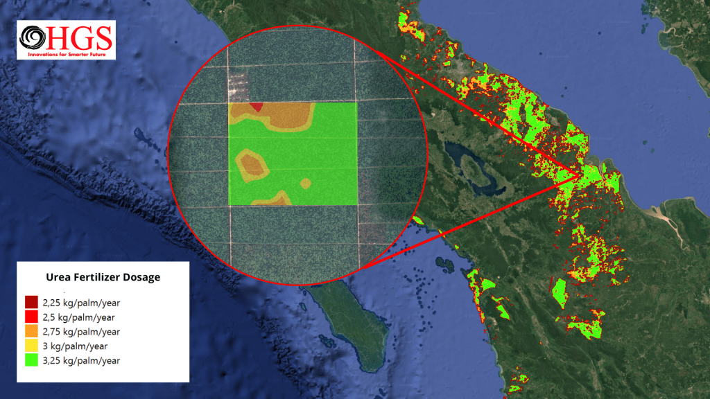
Sample of Fertilization Map
Tree Age Estimation Map
HGS successfully estimated the age of oil palm blocks, categorizing them into key age groups. This information provides a clear overview of plantation demographics, helping guide replanting schedules and long-term productivity planning.
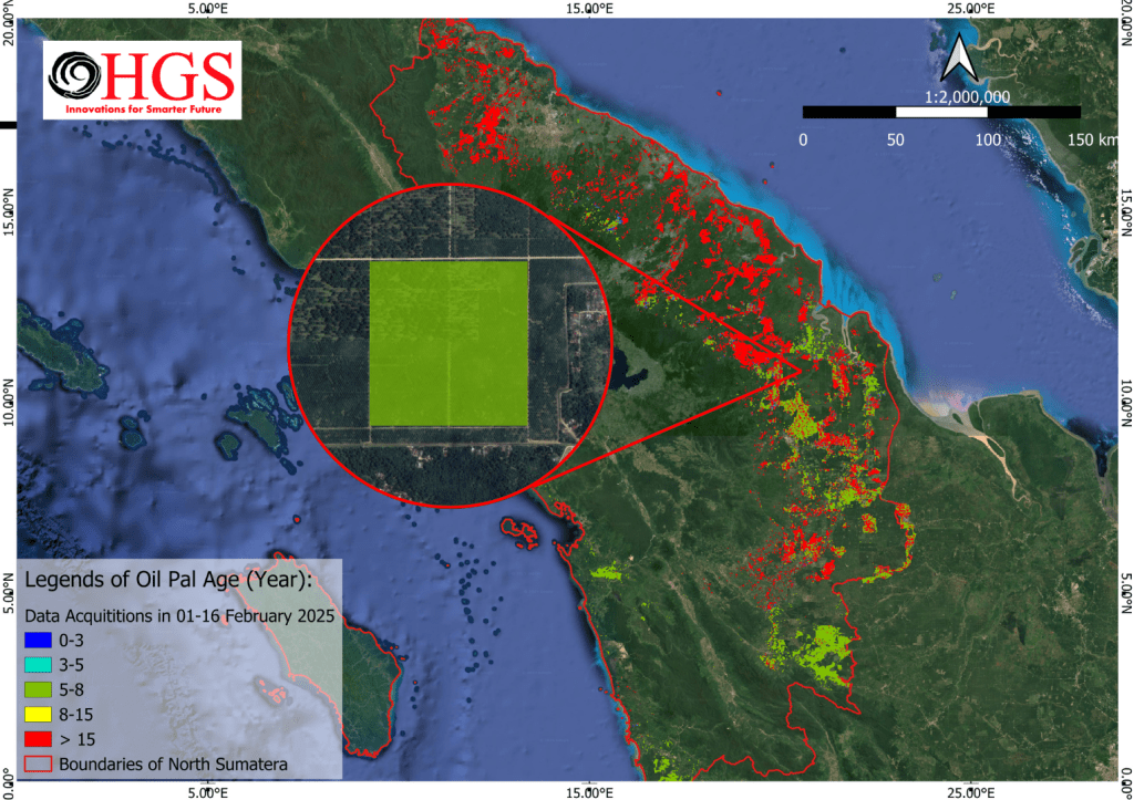
Sample of Tree Age Estimation Map
Disease Map
HGS developed advanced disease risk maps to identify zones showing early signs of vegetation stress. These maps are critical for detecting potential disease outbreaks, especially Ganoderma boninense, which causes basal stem rot (BSR), one of the most devastating diseases in the oil palm sector. In Indonesia, Ganoderma is a persistent critical risk, industry experts estimate losses could exceed IDR 4 trillion annually, affecting over 118,000 hectares. By using these disease risk maps, end-users can prioritize field inspections in red/orange zones, implement targeted preventive treatments, and undertake timely sanitation or replanning interventions. This proactive approach helps limit both agronomic and financial impacts, safeguarding productivity and reducing long-term industry losses.

Sample of Disease Map
Productivity (Yield Estimation) Map
HGS successfully generated productivity maps estimating tons/ha/year across the plantation landscape. These maps can be used by plantation end-users to:
- Identify high-yield zones for targeted optimization and resource allocation, ensuring maximum productivity from the most profitable blocks.
- Detect low-yield or aging plantation blocks that require rejuvenation, replanting, or intensified management interventions.
- Support strategic planning for end-users, including prioritizing investments, scheduling replanting cycles, and benchmarking plantation performance.
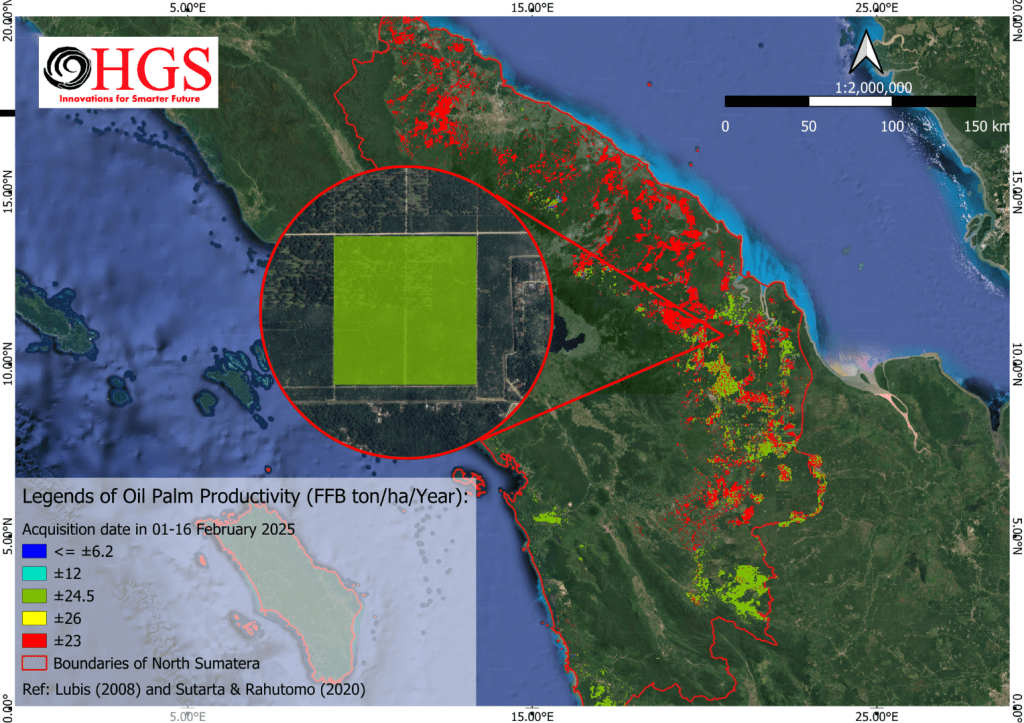
Sample of Productivity (Yield Estimation) Map
The project delivers a set of core maps that enable end-users to optimize resources, enhance operational efficiency, and mitigate risks. By integrating high-resolution satellite imagery, SAR capabilities, and machine learning models, HGS has provided the palm oil industry with a concrete step toward more precise, cost-effective, and sustainable management practices.
The successful delivery of this project reflects positively on the strong collaboration between all parties involved and has been well-received as a valuable contribution to the sector. This achievement lays a solid foundation for future advancements, enabling even more comprehensive and real-time solutions for Indonesia’s agriculture sector especially for palm oil plantation.
Media Contact
Email: info@herdento.com
